IMAGES TAKEN NEAR TO
Seymour Court Road, MARLOW, SL7 3DB
Introduction
This page details the photographs taken nearby to Seymour Court Road, SL7 3DB by members of the Geograph project.
The Geograph project started in 2005 with the aim of publishing, organising and preserving representative images for every square kilometre of Great Britain, Ireland and the Isle of Man.

There are currently over 7.5m images from over14,400 individuals and you can help contribute to the project by visiting https://www.geograph.org.uk
Image Map
Images are licensed for reuse under creativecommons.org/licenses/by-sa/2.0
Notes
- Clicking on the map will re-center to the selected point.
- The higher the marker number, the further away the image location is from the centre of the postcode.
Image Listing (7 Images Found)
Images are licensed for reuse under creativecommons.org/licenses/by-sa/2.0
Image
Details
Distance
1
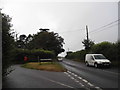
Seymour Court Lane at the junction of Marlow Road
Image: © David Howard
Taken: 12 Jul 2015
0.04 miles
2
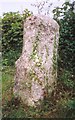
Old Milestone by the B482 near Marlow Bottom
Carved stone post by the B482, in parish of Great Marlow (Wycombe District), Seymour Court Road; Seymour Court Lane junction, on wide grass verge, on East side of road. Marlow pillar, erected by the Gt Marlow & Stokenchurch turnpike trust in the 19th century.
Inscription once read:-
: (STOKENCHURCH : 7) : : (MARLOW : 1) :
Buckinghamshire HER.
HER Number: 1354600000 https://www.heritagegateway.org.uk/Gateway/Results_Single.aspx?uid=MBC25651&resourceID=1024
Milestone Society National ID: BU_MWST02
Image: © A Rosevear & J Higgins
Taken: 1 Aug 2002
0.04 miles
3
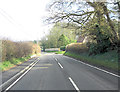
B482 intersection with Seymour Court Lane
Image: © Stuart Logan
Taken: 11 Apr 2013
0.05 miles
4
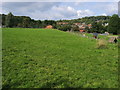
Marlow Bottom playing fields
Marlow Bottom playing fields by the school
Image: © Shaun Ferguson
Taken: 13 Sep 2008
0.22 miles
5
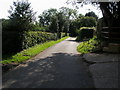
Seymour Court Lane
The Chiltern Way on Seymour Court Lane at High Rews Farm
Image: © Shaun Ferguson
Taken: 13 Sep 2008
0.24 miles
6
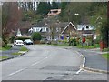
Marlow Bottom
This is the main road, also called Marlow Bottom, that follows the curves of the valley. This is the view from the junction with Highwoods Drive.
Image: © Andrew Smith
Taken: 29 Mar 2008
0.24 miles
7
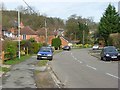
Marlow Bottom
The name of the village, road and valley.
Image: © Andrew Smith
Taken: 29 Mar 2008
0.24 miles