IMAGES TAKEN NEAR TO
Seymour Plain, MARLOW, SL7 3DA
Introduction
This page details the photographs taken nearby to Seymour Plain, SL7 3DA by members of the Geograph project.
The Geograph project started in 2005 with the aim of publishing, organising and preserving representative images for every square kilometre of Great Britain, Ireland and the Isle of Man.

There are currently over 7.5m images from over14,400 individuals and you can help contribute to the project by visiting https://www.geograph.org.uk
Image Map
Images are licensed for reuse under creativecommons.org/licenses/by-sa/2.0
Notes
- Clicking on the map will re-center to the selected point.
- The higher the marker number, the further away the image location is from the centre of the postcode.
Image Listing (3 Images Found)
Images are licensed for reuse under creativecommons.org/licenses/by-sa/2.0
Image
Details
Distance
1

Hill Farm Road. Marlow Bottom
A road of post-war housing descending here from the junction with Monks Hollow. This is the eastern edge of the village.
Image: © Andrew Smith
Taken: 29 Mar 2008
0.23 miles
2
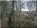
Footpath near the Chiltern Way
Built up area north of Marlow called Marlow Bottom.
Image: © James Emmans
Taken: 25 Feb 2021
0.24 miles
3

Beechtree Avenue
Part of the residential area that has developed above the valley on its northern side. In the background is Hunt's Wood which largely consists of beeches.
Image: © Andrew Smith
Taken: 29 Mar 2008
0.25 miles