IMAGES TAKEN NEAR TO
Mundaydean Lane, MARLOW, SL7 3BT
Introduction
This page details the photographs taken nearby to Mundaydean Lane, SL7 3BT by members of the Geograph project.
The Geograph project started in 2005 with the aim of publishing, organising and preserving representative images for every square kilometre of Great Britain, Ireland and the Isle of Man.

There are currently over 7.5m images from over14,400 individuals and you can help contribute to the project by visiting https://www.geograph.org.uk
Image Map
Images are licensed for reuse under creativecommons.org/licenses/by-sa/2.0
Notes
- Clicking on the map will re-center to the selected point.
- The higher the marker number, the further away the image location is from the centre of the postcode.
Image Listing (13 Images Found)
Images are licensed for reuse under creativecommons.org/licenses/by-sa/2.0
Image
Details
Distance
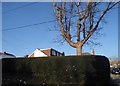
1
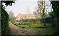
The Old Workhouse
Now private cottages.
Image: © Andrew Smith
Taken: 10 Dec 2005
0.05 miles
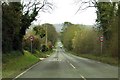
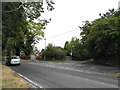
3
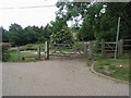
Footpath to Seymour Court
Off Seymour Court Road (B482) the Footpath to Seymour Court
Image: © Shaun Ferguson
Taken: 12 Jun 2009
0.15 miles
4
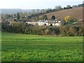
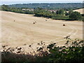
Farmland, Marlow
Town meets country with houses on Berwick Road nestled between arable fields at the entrance to Mundaydean Bottom. The distant view is south of the Thames in Berkshire.
Image: © Andrew Smith
Taken: 29 Mar 2008
0.15 miles
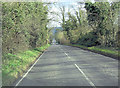
9
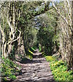
Celandine path, Lower Woodend, Buckinghamshire
Image: © Oswald Bertram
Taken: 14 Apr 2015
0.20 miles