IMAGES TAKEN NEAR TO
Berwick Lane, MARLOW, SL7 3AU
Introduction
This page details the photographs taken nearby to Berwick Lane, SL7 3AU by members of the Geograph project.
The Geograph project started in 2005 with the aim of publishing, organising and preserving representative images for every square kilometre of Great Britain, Ireland and the Isle of Man.

There are currently over 7.5m images from over14,400 individuals and you can help contribute to the project by visiting https://www.geograph.org.uk
Image Map
Images are licensed for reuse under creativecommons.org/licenses/by-sa/2.0
Notes
- Clicking on the map will re-center to the selected point.
- The higher the marker number, the further away the image location is from the centre of the postcode.
Image Listing (16 Images Found)
Images are licensed for reuse under creativecommons.org/licenses/by-sa/2.0
Image
Details
Distance
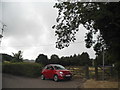
1
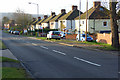
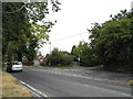
Seymour Court Road, Marlow
Looking down the hill that makes a long but not steep ascent away from the town centre. This is the stretch below Seymour Park Road with Berwick Lane going off to the right in the foreground. The road is the B482.
Image: © Andrew Smith
Taken: 29 Mar 2008
0.08 miles
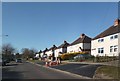
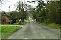
3
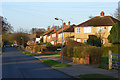
Seymour Court Road, Marlow
The B482 from Lane End and Stokenchurch has just entered the residential confines of Marlow. It is a long, gradual descent into the town centre. The picture was taken in the early morning sunshine on the last day before the start of British summertime.
Image: © Andrew Smith
Taken: 29 Mar 2008
0.09 miles
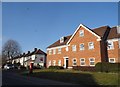
5
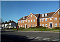
Bank Apartments, Dean Street, Marlow
Image: © Des Blenkinsopp
Taken: 20 Apr 2013
0.16 miles
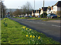
6
Field by Seymour Court Road, Marlow
This is the end of the built up area of Marlow to the northwest.
Image: © David Howard
Taken: 12 Jul 2015
0.16 miles
7
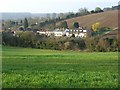
Farmland, Marlow
Town meets country with houses on Berwick Road nestled between arable fields at the entrance to Mundaydean Bottom. The distant view is south of the Thames in Berkshire.
Image: © Andrew Smith
Taken: 29 Mar 2008
0.17 miles
10
Seymour Park Road, Marlow
With the junction with Barnhill Road in the foreground. The southern Chiltern countryside is easily accessed from Marlow and visible in the background here.
Image: © Andrew Smith
Taken: 29 Mar 2008
0.21 miles