IMAGES TAKEN NEAR TO
Malthouse Way, MARLOW, SL7 2UE
Introduction
This page details the photographs taken nearby to Malthouse Way, SL7 2UE by members of the Geograph project.
The Geograph project started in 2005 with the aim of publishing, organising and preserving representative images for every square kilometre of Great Britain, Ireland and the Isle of Man.

There are currently over 7.5m images from over14,400 individuals and you can help contribute to the project by visiting https://www.geograph.org.uk
Image Map (Loading...)


Getting Data...Please wait
Leaflet Map data © OpenStreetMap
Images are licensed for reuse under creativecommons.org/licenses/by-sa/2.0
Notes
- Clicking on the map will re-center to the selected point.
- The higher the marker number, the further away the image location is from the centre of the postcode.
Image Listing (977 Images Found)
Images are licensed for reuse under creativecommons.org/licenses/by-sa/2.0
Image
Details
Distance
1
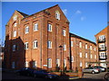
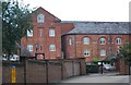
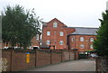
Brew Tower
Marlow was home to Wethered's Brewery which has been tastefully converted into a brewery quarter of modern urban apartments.
Image: © Colin Smith
Taken: 17 Jan 2010
0.01 miles
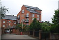
3
The Old Barrel House
The redeveloped Wethereds brewery site.
Image: © N Chadwick
Taken: 26 Aug 2012
0.02 miles
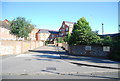
7
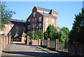
Old Malthouse, Marlow
Part of the old Wethereds Brewery.
Image: © N Chadwick
Taken: 26 Aug 2012
0.02 miles
8
Former Maltings, former Wethered Brewery
Image: © N Chadwick
Taken: 25 Aug 2013
0.02 miles
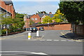
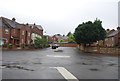
10
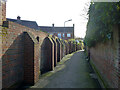
Portlands Alley, Marlow
From West Street to Pound Lane.
Image: © Robin Webster
Taken: 2 Feb 2014
0.03 miles