IMAGES TAKEN NEAR TO
Harleyford, Henley Road, MARLOW, SL7 2SL
Introduction
This page details the photographs taken nearby to Harleyford, Henley Road, SL7 2SL by members of the Geograph project.
The Geograph project started in 2005 with the aim of publishing, organising and preserving representative images for every square kilometre of Great Britain, Ireland and the Isle of Man.

There are currently over 7.5m images from over14,400 individuals and you can help contribute to the project by visiting https://www.geograph.org.uk
Image Map
Images are licensed for reuse under creativecommons.org/licenses/by-sa/2.0
Notes
- Clicking on the map will re-center to the selected point.
- The higher the marker number, the further away the image location is from the centre of the postcode.
Image Listing (10 Images Found)
Images are licensed for reuse under creativecommons.org/licenses/by-sa/2.0
Image
Details
Distance
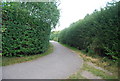
2
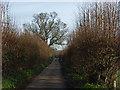
Harleyford Lane
Looking towards Marlow from East Lodge.
Image: © Andrew Smith
Taken: 10 Dec 2006
0.10 miles
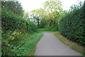
3
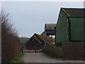
Lower Grounds Farm
On the footpath, a private road, entering the farm from the north.
Image: © Andrew Smith
Taken: 10 Dec 2006
0.11 miles
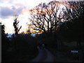
4
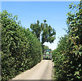
Harleyford Lane wasn't built for this
There follows an unscheduled dive into a not very welcoming hedge.
Image: © Des Blenkinsopp
Taken: 15 Aug 2016
0.15 miles
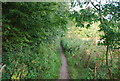
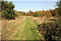
9
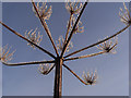
A frosty umbellifer
Hogweed or something similar.
Image: © Andrew Smith
Taken: 10 Dec 2006
0.23 miles
10
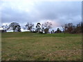
A private golf course above Harleyford Lane
Image: © Andrew Smith
Taken: 27 Dec 2005
0.24 miles