IMAGES TAKEN NEAR TO
Chalkpit Lane, MARLOW, SL7 2JE
Introduction
This page details the photographs taken nearby to Chalkpit Lane, SL7 2JE by members of the Geograph project.
The Geograph project started in 2005 with the aim of publishing, organising and preserving representative images for every square kilometre of Great Britain, Ireland and the Isle of Man.

There are currently over 7.5m images from over14,400 individuals and you can help contribute to the project by visiting https://www.geograph.org.uk
Image Map
Images are licensed for reuse under creativecommons.org/licenses/by-sa/2.0
Notes
- Clicking on the map will re-center to the selected point.
- The higher the marker number, the further away the image location is from the centre of the postcode.
Image Listing (7 Images Found)
Images are licensed for reuse under creativecommons.org/licenses/by-sa/2.0
Image
Details
Distance
1
Elmdon Cottage
The small rural cottage appears on the OS map. Photo from the footpath.
Image: © James Emmans
Taken: 29 Jul 2020
0.07 miles
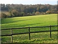
2
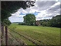
Field and Houses next to Chalkpit Lane
Southern view from footpath.
Image: © James Emmans
Taken: 29 Jul 2020
0.11 miles
3
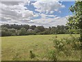
View North from Footpath
Large field between Bovington Green and Marlow.
Image: © James Emmans
Taken: 29 Jul 2020
0.14 miles

5
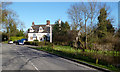
The Royal Oak, Bovingdon Green
Country pub on the edge of Marlow.
Image: © Des Blenkinsopp
Taken: 20 Apr 2013
0.22 miles
6
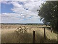
Pasture and woodland, Marlow
Looking across to Blount's Wood from the bridleway below High Rews Farm. The intervening valley is the lower end of Mundaydean Bottom.
Image: © Andrew Smith
Taken: 29 Mar 2008
0.23 miles
7
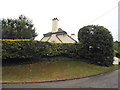
Side of house on Chalkpit Lane, Marlow
Image: © David Howard
Taken: 12 Jul 2015
0.24 miles