IMAGES TAKEN NEAR TO
Pound Lane, MARLOW, SL7 2FW
Introduction
This page details the photographs taken nearby to Pound Lane, SL7 2FW by members of the Geograph project.
The Geograph project started in 2005 with the aim of publishing, organising and preserving representative images for every square kilometre of Great Britain, Ireland and the Isle of Man.

There are currently over 7.5m images from over14,400 individuals and you can help contribute to the project by visiting https://www.geograph.org.uk
Image Map
Images are licensed for reuse under creativecommons.org/licenses/by-sa/2.0
Notes
- Clicking on the map will re-center to the selected point.
- The higher the marker number, the further away the image location is from the centre of the postcode.
Image Listing (1049 Images Found)
Images are licensed for reuse under creativecommons.org/licenses/by-sa/2.0
Image
Details
Distance
5
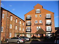
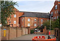
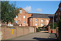
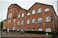
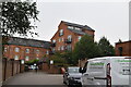
Brewery Quarter, Marlow
The former Wethered's Brewery has been converted into a tasteful housing development in central Marlow.
Image: © Colin Smith
Taken: 17 Jan 2010
0.03 miles
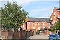
8
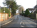
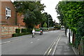
Pound Lane
Looking back towards the High Street from the car park with the same name.
Image: © Mr Ignavy
Taken: 2 Jan 2008
0.03 miles