IMAGES TAKEN NEAR TO
Hayes Place, MARLOW, SL7 2FU
Introduction
This page details the photographs taken nearby to Hayes Place, SL7 2FU by members of the Geograph project.
The Geograph project started in 2005 with the aim of publishing, organising and preserving representative images for every square kilometre of Great Britain, Ireland and the Isle of Man.

There are currently over 7.5m images from over14,400 individuals and you can help contribute to the project by visiting https://www.geograph.org.uk
Image Map
Images are licensed for reuse under creativecommons.org/licenses/by-sa/2.0
Notes
- Clicking on the map will re-center to the selected point.
- The higher the marker number, the further away the image location is from the centre of the postcode.
Image Listing (361 Images Found)
Images are licensed for reuse under creativecommons.org/licenses/by-sa/2.0
Image
Details
Distance
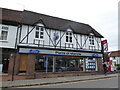
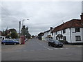
2
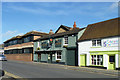
Oxford Road at the corner of West Street, Marlow
Image: © David Howard
Taken: 12 Jul 2015
0.02 miles
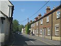
3
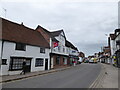
Looking east-northeast along West Street
Image: © Basher Eyre
Taken: 5 Sep 2020
0.02 miles
4
Looking west-southwest along West Street
Image: © Basher Eyre
Taken: 5 Sep 2020
0.02 miles
5
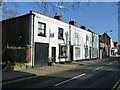
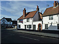
92 and down, West Street, Marlow
All grade II listed buildings.
Image: © Robin Webster
Taken: 2 Feb 2014
0.03 miles
7
Looking from West Street into Oxford Road
Image: © Basher Eyre
Taken: 5 Sep 2020
0.03 miles
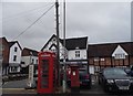
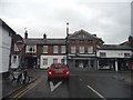
9
Clayton's, Marlow
On Oxford Road. Formerly the Clayton Arms.
Image: © Robin Webster
Taken: 2 Feb 2014
0.04 miles
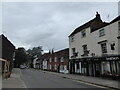
10
Crown Cottage, Marlow
On the corner of West Street and Oxford Street, a grade II listed building, 18th century.
Image: © Robin Webster
Taken: 2 Feb 2014
0.04 miles