IMAGES TAKEN NEAR TO
Henley Road, MARLOW, SL7 2DA
Introduction
This page details the photographs taken nearby to Henley Road, SL7 2DA by members of the Geograph project.
The Geograph project started in 2005 with the aim of publishing, organising and preserving representative images for every square kilometre of Great Britain, Ireland and the Isle of Man.

There are currently over 7.5m images from over14,400 individuals and you can help contribute to the project by visiting https://www.geograph.org.uk
Image Map
Images are licensed for reuse under creativecommons.org/licenses/by-sa/2.0
Notes
- Clicking on the map will re-center to the selected point.
- The higher the marker number, the further away the image location is from the centre of the postcode.
Image Listing (15 Images Found)
Images are licensed for reuse under creativecommons.org/licenses/by-sa/2.0
Image
Details
Distance
1

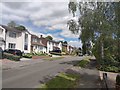
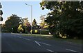
Houses at Pound Lane
The western end of Pound Lane has a development on 1980s houses, with some space and greenery around. Shakespeare's Way makes a reasonably pleasant entrance to Marlow.
Image: © Graham Horn
Taken: 25 May 2013
0.14 miles
2
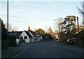
#2 Bream Close at Pound Lane junction
Image: © Roger Templeman
Taken: 10 Oct 2018
0.17 miles
4
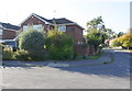
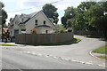
Marlow - Highfield Park
Detached house with extension on the edge of Marlow town.
Image: © James Emmans
Taken: 29 Jul 2020
0.18 miles
5
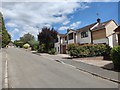
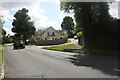
Houses on Pound Lane
Shakespeare's Way makes a reasonably pleasant entrance to Marlow along this estate road from the west.
Image: © Graham Horn
Taken: 25 May 2013
0.20 miles
8
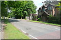
Henley Road at the junction of Highfield Park
Image: © David Howard
Taken: 12 Jun 2022
0.21 miles
10
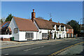
The Hand and Flowers, Marlow
A pub on West Street. Older part 18th century, grade II listed, together with the house to the right.
Image: © Robin Webster
Taken: 2 Feb 2014
0.21 miles