IMAGES TAKEN NEAR TO
Davis Close, MARLOW, SL7 1SY
Introduction
This page details the photographs taken nearby to Davis Close, SL7 1SY by members of the Geograph project.
The Geograph project started in 2005 with the aim of publishing, organising and preserving representative images for every square kilometre of Great Britain, Ireland and the Isle of Man.

There are currently over 7.5m images from over14,400 individuals and you can help contribute to the project by visiting https://www.geograph.org.uk
Image Map
Images are licensed for reuse under creativecommons.org/licenses/by-sa/2.0
Notes
- Clicking on the map will re-center to the selected point.
- The higher the marker number, the further away the image location is from the centre of the postcode.
Image Listing (718 Images Found)
Images are licensed for reuse under creativecommons.org/licenses/by-sa/2.0
Image
Details
Distance
5
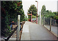
Marlow station, 2002
View east from the buffers of the terminus of the ex-GWR branch from Bourne End and Maidenhead. This simple structure was only built in 7/67, served by an auto-train from Maidenhead via Bourne End. It is on the site of the goods yard of the original, grander Marlow terminus. The branch from High Wycombe to Maidenhead was cut back to Bourne End in 5/70.
Image: © Ben Brooksbank
Taken: 22 Sep 2002
0.07 miles