IMAGES TAKEN NEAR TO
Lock Road, MARLOW, SL7 1RD
Introduction
This page details the photographs taken nearby to Lock Road, SL7 1RD by members of the Geograph project.
The Geograph project started in 2005 with the aim of publishing, organising and preserving representative images for every square kilometre of Great Britain, Ireland and the Isle of Man.

There are currently over 7.5m images from over14,400 individuals and you can help contribute to the project by visiting https://www.geograph.org.uk
Image Map
Images are licensed for reuse under creativecommons.org/licenses/by-sa/2.0
Notes
- Clicking on the map will re-center to the selected point.
- The higher the marker number, the further away the image location is from the centre of the postcode.
Image Listing (182 Images Found)
Images are licensed for reuse under creativecommons.org/licenses/by-sa/2.0
Image
Details
Distance
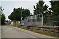
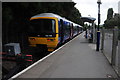
4
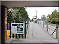
Marlow Station
Terminus of the single-track line from Maidenhead; offering hourly services there, operated by GWR.
Image: © Mike Faherty
Taken: 6 Oct 2018
0.03 miles
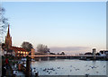
6
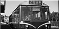
A diesel train at Marlow Station circa 1960
Image: © Antony Ewart Smith
Taken: Unknown
0.04 miles
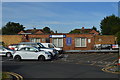
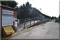
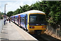
8
Marlow Station
Train at the end of the line in Marlow Station.
Image: © Philip Halling
Taken: 6 Aug 2011
0.04 miles
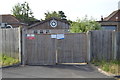
9
Marlow Railway Station
The station is the terminus of the branch from Maidenhead. The line runs via Bourne End where a reversal is required.
Image: © David Robinson
Taken: 27 Jun 2014
0.05 miles