IMAGES TAKEN NEAR TO
St. Peter Street, MARLOW, SL7 1QA
Introduction
This page details the photographs taken nearby to St. Peter Street, SL7 1QA by members of the Geograph project.
The Geograph project started in 2005 with the aim of publishing, organising and preserving representative images for every square kilometre of Great Britain, Ireland and the Isle of Man.

There are currently over 7.5m images from over14,400 individuals and you can help contribute to the project by visiting https://www.geograph.org.uk
Image Map
Images are licensed for reuse under creativecommons.org/licenses/by-sa/2.0
Notes
- Clicking on the map will re-center to the selected point.
- The higher the marker number, the further away the image location is from the centre of the postcode.
Image Listing (912 Images Found)
Images are licensed for reuse under creativecommons.org/licenses/by-sa/2.0
Image
Details
Distance
1
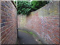
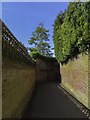
Seven Corners Passage, Marlow
In this area there is no towpath by the river. The horses had to be unharnessed and taken through this narrow passage which winds around the backs of houses, while the boats were hauled by ropes hundreds of yards long.
Image: © David Hawgood
Taken: 14 Aug 2012
0.01 miles
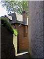
5
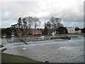
Marlow Weir
Taken from Compleat Angler Hotel
Image: © Andrew Davis
Taken: 22 Jan 2009
0.03 miles
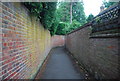
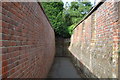
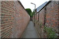
6
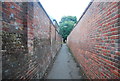
All walled in
The Thames Path between St Peter's St and Mill Rd.
Image: © N Chadwick
Taken: 25 Aug 2013
0.03 miles