IMAGES TAKEN NEAR TO
Westhorpe Road, MARLOW, SL7 1LD
Introduction
This page details the photographs taken nearby to Westhorpe Road, SL7 1LD by members of the Geograph project.
The Geograph project started in 2005 with the aim of publishing, organising and preserving representative images for every square kilometre of Great Britain, Ireland and the Isle of Man.

There are currently over 7.5m images from over14,400 individuals and you can help contribute to the project by visiting https://www.geograph.org.uk
Image Map
Images are licensed for reuse under creativecommons.org/licenses/by-sa/2.0
Notes
- Clicking on the map will re-center to the selected point.
- The higher the marker number, the further away the image location is from the centre of the postcode.
Image Listing (16 Images Found)
Images are licensed for reuse under creativecommons.org/licenses/by-sa/2.0
Image
Details
Distance
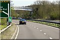
1
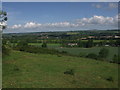
Marlow from the high ground above Cock Marsh
The Marlow bypass (A404) runs across the centre of the view, before climbing the hill on the right to join the M40 motorway at High Wycombe
Image: © Mick Crawley
Taken: 5 May 2004
0.02 miles
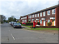
4
Marlow - Gunthorpe Road
Housing estate on the outskirts of Marlow. Two red kites can be seen as dots in the sky.
The birds are permanent residents as can be seen on this map link -
https://upload.wikimedia.org/wikipedia/commons/5/5c/Milvus_milvus_distr02.png
https://en.wikipedia.org/wiki/Red_kite
Image: © James Emmans
Taken: 28 Jul 2020
0.10 miles
5
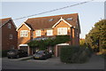
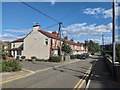
Nos. 89 and 91 Newtown Road at Quarrydale Drive junction
Image: © Roger Templeman
Taken: 10 Oct 2018
0.11 miles
6
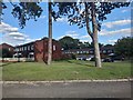
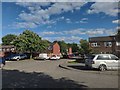
Modern Housing Car Park
Houses on Savill Way next to the Thames Industrial Estate.
Image: © James Emmans
Taken: 28 Jul 2020
0.12 miles
7
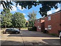
Gunthorpe Road, Marlow
Part of a relatively modern residential area on the eastern edge of the town.
Image: © Andrew Smith
Taken: 29 Mar 2008
0.15 miles
9
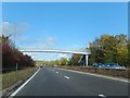
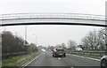
Footbridge over A404 east of Marlow
The bridge carries a footpath from Marlow to Little Marlow; the hedges and shrubs on the left screen housing estates from the sound of the traffic.
Image: © David Smith
Taken: 26 Oct 2011
0.24 miles