IMAGES TAKEN NEAR TO
Newfield Road, MARLOW, SL7 1JW
Introduction
This page details the photographs taken nearby to Newfield Road, SL7 1JW by members of the Geograph project.
The Geograph project started in 2005 with the aim of publishing, organising and preserving representative images for every square kilometre of Great Britain, Ireland and the Isle of Man.

There are currently over 7.5m images from over14,400 individuals and you can help contribute to the project by visiting https://www.geograph.org.uk
Image Map
Images are licensed for reuse under creativecommons.org/licenses/by-sa/2.0
Notes
- Clicking on the map will re-center to the selected point.
- The higher the marker number, the further away the image location is from the centre of the postcode.
Image Listing (17 Images Found)
Images are licensed for reuse under creativecommons.org/licenses/by-sa/2.0
Image
Details
Distance
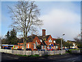
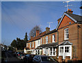
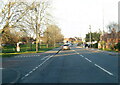
2
Nos. 89 and 91 Newtown Road at Quarrydale Drive junction
Image: © Roger Templeman
Taken: 10 Oct 2018
0.16 miles
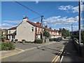
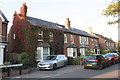
3
Foxes Piece, Marlow
A small estate parallel to the main road
Image: © David Howard
Taken: 12 Jul 2015
0.19 miles
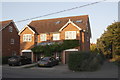
7
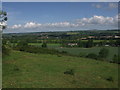
Marlow from the high ground above Cock Marsh
The Marlow bypass (A404) runs across the centre of the view, before climbing the hill on the right to join the M40 motorway at High Wycombe
Image: © Mick Crawley
Taken: 5 May 2004
0.21 miles
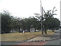
9
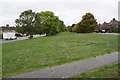
Grass area between Marlow Road and Little Marlow Road
Image: © Roger Templeman
Taken: 6 Oct 2018
0.21 miles