IMAGES TAKEN NEAR TO
Beeching Stoke, MARLOW, SL7 1JH
Introduction
This page details the photographs taken nearby to Beeching Stoke, SL7 1JH by members of the Geograph project.
The Geograph project started in 2005 with the aim of publishing, organising and preserving representative images for every square kilometre of Great Britain, Ireland and the Isle of Man.

There are currently over 7.5m images from over14,400 individuals and you can help contribute to the project by visiting https://www.geograph.org.uk
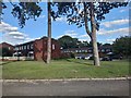
Image Map
Images are licensed for reuse under creativecommons.org/licenses/by-sa/2.0
Notes
- Clicking on the map will re-center to the selected point.
- The higher the marker number, the further away the image location is from the centre of the postcode.
Image Listing (19 Images Found)
Images are licensed for reuse under creativecommons.org/licenses/by-sa/2.0
Image
Details
Distance
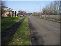
1
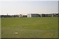
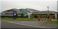
Marlow
Looking west towards Great Marlow School from the roundabout on the A4155. Most of this square is residential.
Image: © Brendan and Ruth McCartney
Taken: 21 Apr 2005
0.05 miles
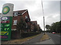
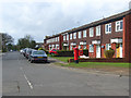
5

Marlow fire station
Marlow fire station, Parkway, Marlow, Buckinghamshire
Image: © Kevin Hale
Taken: 18 Jun 2007
0.17 miles
6
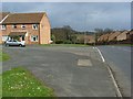
Wiltshire Drive, Marlow
At the junction with Eliot Drive in this not so nice part of the town.
Image: © Andrew Smith
Taken: 29 Mar 2008
0.17 miles
7
Gunthorpe Road, Marlow
Part of a relatively modern residential area on the eastern edge of the town.
Image: © Andrew Smith
Taken: 29 Mar 2008
0.17 miles
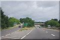
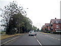
8
The Parkway
The Parkway running parallel to the A404
Image: © Shaun Ferguson
Taken: 6 Feb 2010
0.17 miles