IMAGES TAKEN NEAR TO
Beaumont Rise, MARLOW, SL7 1EE
Introduction
This page details the photographs taken nearby to Beaumont Rise, SL7 1EE by members of the Geograph project.
The Geograph project started in 2005 with the aim of publishing, organising and preserving representative images for every square kilometre of Great Britain, Ireland and the Isle of Man.

There are currently over 7.5m images from over14,400 individuals and you can help contribute to the project by visiting https://www.geograph.org.uk
Image Map
Images are licensed for reuse under creativecommons.org/licenses/by-sa/2.0
Notes
- Clicking on the map will re-center to the selected point.
- The higher the marker number, the further away the image location is from the centre of the postcode.
Image Listing (323 Images Found)
Images are licensed for reuse under creativecommons.org/licenses/by-sa/2.0
Image
Details
Distance
3
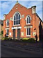
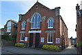
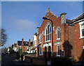
Marlow Baptist Church, Glade Road, Marlow, Bucks
The church describes itself as "We are a small, friendly evangelical Baptist Church situated near to Marlow Railway Station." To an outside observer it would appear to be more evangelical in emphasis than Baptist. It is not affiliated to the Baptist Union but is linked with the Fellowship of Independent Evangelical churches (FIEC) - which is a network of over 500 similar churches in the country.
Image: © P L Chadwick
Taken: 4 Nov 2017
0.05 miles
5
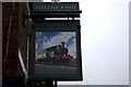
Marlow Donkey sign
This is one of the better railway-themed pub signs.
Image: © Robert Eva
Taken: 11 Mar 2017
0.05 miles
7
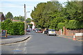
The Marlow Donkey (1), Station Road, Marlow, Bucks
Large Greene King public house near the railway station. It has a large garden and a conservatory. It serves lunchtime and evening meals. It was refurbished in May 2015.
Image
Image
Image: © P L Chadwick
Taken: 4 Nov 2017
0.06 miles
9
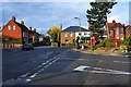
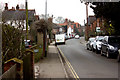
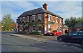
Road junction by Marlow Donkey public house, Marlow, Bucks
The road on the immediate right is Station Approach. To its left is Lock Road.
Image: © P L Chadwick
Taken: 4 Nov 2017
0.06 miles