IMAGES TAKEN NEAR TO
Institute Road, MARLOW, SL7 1BN
Introduction
This page details the photographs taken nearby to Institute Road, SL7 1BN by members of the Geograph project.
The Geograph project started in 2005 with the aim of publishing, organising and preserving representative images for every square kilometre of Great Britain, Ireland and the Isle of Man.

There are currently over 7.5m images from over14,400 individuals and you can help contribute to the project by visiting https://www.geograph.org.uk
Image Map (Loading...)


Getting Data...Please wait
Leaflet Map data © OpenStreetMap
Images are licensed for reuse under creativecommons.org/licenses/by-sa/2.0
Notes
- Clicking on the map will re-center to the selected point.
- The higher the marker number, the further away the image location is from the centre of the postcode.
Image Listing (933 Images Found)
Images are licensed for reuse under creativecommons.org/licenses/by-sa/2.0
Image
Details
Distance
1
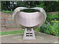
The May Balfour Garden (4) - Sundial
The sundial was created by Edwin Russell FRBS, and stands in the north east corner of the garden, facing due south.
Image: © John S Turner
Taken: 18 Aug 2014
0.02 miles
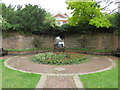
2
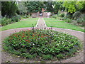
The May Balfour Garden (3)
Looking along the garden towards Institute Road. The Edwin Russell FRBS sundial is in the right hand corner.
Image: © John S Turner
Taken: 18 Aug 2014
0.03 miles
3
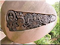
The May Balfour Garden (5) - Sundial
This artwork is on the west side of the sundial, and I think is Hindu? See also Image
Image: © John S Turner
Taken: 18 Aug 2014
0.03 miles
4
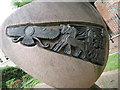
The May Balfour Garden (6) - Sundial
This artwork is on the east side of the sundial, and I think is Egyptian? See also Image
Image: © John S Turner
Taken: 18 Aug 2014
0.03 miles
5
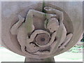
The May Balfour Garden (7) - Sundial
These 'twins' are underneath the north side of the sundial, and presumably are an astrological reference. See also: Image
Image: © John S Turner
Taken: 18 Aug 2014
0.03 miles
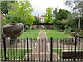
6
The May Balfour Garden (2)
The southern end of the garden with Marlow Place beyond.
Image: © John S Turner
Taken: 18 Aug 2014
0.03 miles
7
The May Balfour Garden (1)
Looking SSW along The May Balfour Garden.
Image: © John S Turner
Taken: 18 Aug 2014
0.03 miles
8
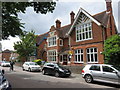
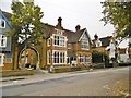
Marlow Library - formerly the Institute
Looking across Institute Road towards the library which was formerly the Institute. The library is attached by an arch to the former HQ of the 1st Bucks R.V. Corps., which was built in 1889, so both buildings may be of a similar date. Image
Image: © John S Turner
Taken: 18 Aug 2014
0.03 miles
9
Marlow Library
Library and information centre on Institute Road: https://www.buckscc.gov.uk/services/libraries/find-a-library/marlow/
Image: © Mike Faherty
Taken: 6 Oct 2018
0.03 miles
10
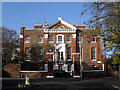
Marlow Place
Marlow Place, one of the most interesting and historic buildings in the town. It is a fine piece of architecture, built circa 1721 for John Wallop, First Earl of Portsmouth, of a type unique in Buckinghamshire, and has been ascribed to Thomas Archer. Marlow Place was obtained by the Royal Military Academy as an annex to house the overflow from the junior department at Remnantz in West Street whilst it was located in Marlow. It has recently been restored and is now used as company offices.
This info. courtesy of the Marlow History website.
Image: © Des Blenkinsopp
Taken: 20 Nov 2010
0.04 miles