IMAGES TAKEN NEAR TO
Liston Road, MARLOW, SL7 1AG
Introduction
This page details the photographs taken nearby to Liston Road, SL7 1AG by members of the Geograph project.
The Geograph project started in 2005 with the aim of publishing, organising and preserving representative images for every square kilometre of Great Britain, Ireland and the Isle of Man.

There are currently over 7.5m images from over14,400 individuals and you can help contribute to the project by visiting https://www.geograph.org.uk
Image Map
Images are licensed for reuse under creativecommons.org/licenses/by-sa/2.0
Notes
- Clicking on the map will re-center to the selected point.
- The higher the marker number, the further away the image location is from the centre of the postcode.
Image Listing (475 Images Found)
Images are licensed for reuse under creativecommons.org/licenses/by-sa/2.0
Image
Details
Distance
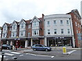
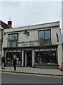
2
Looking across Spittal Street towards Morris Place
Image: © Basher Eyre
Taken: 5 Sep 2020
0.06 miles
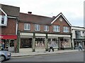
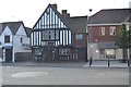
5
Market Square, Marlow
Roundabout with obelisk at the tri-point where three streets (High, Spittal and West) meet in central Marlow.
Image: © Colin Smith
Taken: 17 Jan 2010
0.07 miles
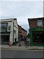
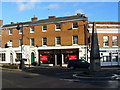
7
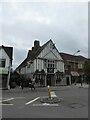
Looking from Dean Street towards The Oarsman
Image: © Basher Eyre
Taken: 5 Sep 2020
0.07 miles
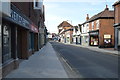
8
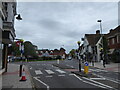
Zebra crossing at the north-eastern end of Spittal Street
Image: © Basher Eyre
Taken: 5 Sep 2020
0.07 miles