IMAGES TAKEN NEAR TO
The Moor, MAIDENHEAD, SL6 9SB
Introduction
This page details the photographs taken nearby to The Moor, SL6 9SB by members of the Geograph project.
The Geograph project started in 2005 with the aim of publishing, organising and preserving representative images for every square kilometre of Great Britain, Ireland and the Isle of Man.

There are currently over 7.5m images from over14,400 individuals and you can help contribute to the project by visiting https://www.geograph.org.uk
Image Map
Images are licensed for reuse under creativecommons.org/licenses/by-sa/2.0
Notes
- Clicking on the map will re-center to the selected point.
- The higher the marker number, the further away the image location is from the centre of the postcode.
Image Listing (154 Images Found)
Images are licensed for reuse under creativecommons.org/licenses/by-sa/2.0
Image
Details
Distance
1
Cookham: Flood defence wall
Cookham has always been prone to flooding from the River Thames, and the flood events of November 1894 and March 1947 caused severe inundation and damage. This is the flood defence wall along the western side of Cookham, constructed by the Environment Agency in 2002/3. Beyond the wall to the left is Cookham Moor leading down to the Thames in the distance, marked by the sails on dinghies. On this side to the right is the protected area of the town.
Image: © Nigel Cox
Taken: 8 Jul 2007
0.01 miles
2
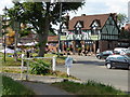
Cookham - The Crown
Public house that was quite popular on a hot Saturday afternoon and provided a refreshing pint of lime and soda.
Image: © Chris Allen
Taken: 23 Jul 2016
0.02 miles
3
The Crown, Cookham, December 2020
Still in the grip of 2020's coronavirus epidemic, The Crown, like all pubs and a host of other businesses has had to close its doors until things get better.
Image: © Des Blenkinsopp
Taken: 1 Dec 2020
0.02 miles
4
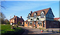
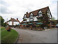
The Crown, Cookham
Half-timbered pub by Cookham Moor. It gets a good trade by virtue of the large car park nearby which serves visitors to this popular village and its reach of the Thames.
Image: © Colin Smith
Taken: 4 Aug 2007
0.02 miles
5
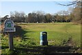
Cookham Moor
Part of Cookham Common owned by the National Trust.
Image: © Bill Boaden
Taken: 26 Jan 2024
0.02 miles
6
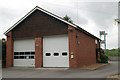
Cookham Fire Station
Cookham Fire Station, Berries Road, Cookham, Berkshire
Image: © Kevin Hale
Taken: 8 May 2007
0.03 miles
7
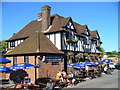
The Crown - Cookham
They may not have a view of the river but they do have a large area of The Moor where kids can safely play whilst the oldies drink and eat and chat...
Image: © Mr Ignavy
Taken: 17 Oct 2009
0.03 miles
8
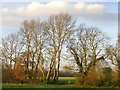
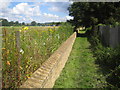
View towards Marsh Meadow from the Cookham Moor causeway
The Thames flood-plain to the west of Cookham village - seen in the rather feeble light of a December afternoon. Marsh Meadow is an extensive stretch of pasture land, owned by a local farm which at present grants public access.
Image: © Stefan Czapski
Taken: 9 Dec 2013
0.04 miles
9
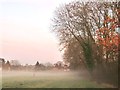
Mist over Marsh Meadow, Cookham - on a December afternoon
Late afternoon in the second week of December - and walkies-time for a local dog. As I made my way back to Cookham across Marsh Meadow mist began to rise - first as narrow strands at about shoulder height, but soon deepening.
Most of the trees are now leafless - though not the oaks.
Image: © Stefan Czapski
Taken: 9 Dec 2013
0.05 miles
10
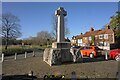
War memorial in Cookham
At the end of High Street overlooking the Common.
Image: © Bill Boaden
Taken: 26 Jan 2024
0.06 miles