IMAGES TAKEN NEAR TO
Ray Mill Road East, MAIDENHEAD, SL6 8TW
Introduction
This page details the photographs taken nearby to Ray Mill Road East, SL6 8TW by members of the Geograph project.
The Geograph project started in 2005 with the aim of publishing, organising and preserving representative images for every square kilometre of Great Britain, Ireland and the Isle of Man.

There are currently over 7.5m images from over14,400 individuals and you can help contribute to the project by visiting https://www.geograph.org.uk
Image Map
Images are licensed for reuse under creativecommons.org/licenses/by-sa/2.0
Notes
- Clicking on the map will re-center to the selected point.
- The higher the marker number, the further away the image location is from the centre of the postcode.
Image Listing (98 Images Found)
Images are licensed for reuse under creativecommons.org/licenses/by-sa/2.0
Image
Details
Distance
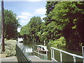
3
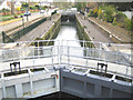
River Thames: Boulter's Lock, Maidenhead
The lock was built in 1772. Viewed from the road bridge to Boulter's and Ray Mill Islands, the latter was once the home of the broadcaster Richard Dimbleby. The road on the left is the A4094 Cookham Road.
Image: © Nigel Cox
Taken: 19 Apr 2006
0.04 miles
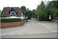
4
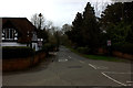
Ray Mill Road East
Taken from Boulter's Lock
Image: © Robert Eva
Taken: 11 Mar 2017
0.04 miles