IMAGES TAKEN NEAR TO
Hazell Close, MAIDENHEAD, SL6 8SH
Introduction
This page details the photographs taken nearby to Hazell Close, SL6 8SH by members of the Geograph project.
The Geograph project started in 2005 with the aim of publishing, organising and preserving representative images for every square kilometre of Great Britain, Ireland and the Isle of Man.

There are currently over 7.5m images from over14,400 individuals and you can help contribute to the project by visiting https://www.geograph.org.uk
Image Map
Images are licensed for reuse under creativecommons.org/licenses/by-sa/2.0
Notes
- Clicking on the map will re-center to the selected point.
- The higher the marker number, the further away the image location is from the centre of the postcode.
Image Listing (47 Images Found)
Images are licensed for reuse under creativecommons.org/licenses/by-sa/2.0
Image
Details
Distance
1
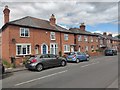
Ray Mill Road West
Old cottages in Maidenhead.
Image: © James Emmans
Taken: 28 Jul 2020
0.04 miles
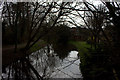
2
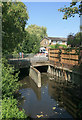
Strand Water under Ray Mill Road
Strand Water is a small stream collecting water from various ditches and drains around the gravel pits to the north of here.
Looking very much like a neglected urban watercourse in this picture, it has actually been incorporated into a pleasant waterside park just downstream of here.
Image: © Des Blenkinsopp
Taken: 29 Jul 2014
0.09 miles
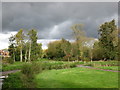
3
Path by Strand Water, north of Ray Mill Road West.
Image: © Robert Eva
Taken: 11 Mar 2017
0.10 miles
4
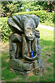
Carving with a Can
Urban artworks have a hard time. This can of Tennent's Super Lager is an inevitable addition I suppose, given the absence of traffic cones round here.
This carving has been made from an old tree stump.
Image: © Des Blenkinsopp
Taken: 29 Jul 2014
0.10 miles
6
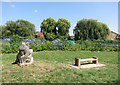
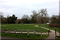
Carving and Bench
This is on North Town Moor open space. The carving looks to have been made in situ from an old tree stump.
Allotments in the background.
Image: © Des Blenkinsopp
Taken: 30 Jul 2014
0.10 miles
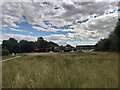
8
North Town Moor
National Trust open space.
Image: © don cload
Taken: 1 Nov 2012
0.11 miles
9
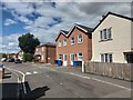
North Town Road
Houses in an area of Maidenhead called North Town.
Image: © James Emmans
Taken: 28 Jul 2020
0.13 miles
10
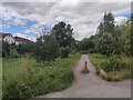
Cycle Path 50 heading North
A partly off-road cycle route from Maidenhead to Cookham.
Image: © James Emmans
Taken: 28 Jul 2020
0.13 miles