IMAGES TAKEN NEAR TO
Ray Lodge Mews, MAIDENHEAD, SL6 8NF
Introduction
This page details the photographs taken nearby to Ray Lodge Mews, SL6 8NF by members of the Geograph project.
The Geograph project started in 2005 with the aim of publishing, organising and preserving representative images for every square kilometre of Great Britain, Ireland and the Isle of Man.

There are currently over 7.5m images from over14,400 individuals and you can help contribute to the project by visiting https://www.geograph.org.uk
Image Map
Images are licensed for reuse under creativecommons.org/licenses/by-sa/2.0
Notes
- Clicking on the map will re-center to the selected point.
- The higher the marker number, the further away the image location is from the centre of the postcode.
Image Listing (130 Images Found)
Images are licensed for reuse under creativecommons.org/licenses/by-sa/2.0
Image
Details
Distance
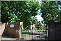
1
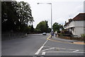
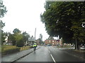
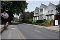
Ray Drive, Maidenhead
Ray Drive in Maidenhead pictured at the junction with Ray Park Avenue.
Image: © Philip Halling
Taken: 6 Aug 2011
0.10 miles
2
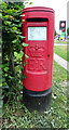
Elizabeth II postbox on Ray Park Avenue, Maidenhead
Postbox No. SL6 3.
Image: © JThomas
Taken: 25 May 2022
0.11 miles
4
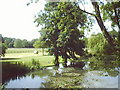
Up river from Maidenhead Bridge
Taken while on a walk along the river from Maidenhead bridge, Berkshire.
Image: © Bob Sixpence
Taken: 12 Jul 2003
0.12 miles
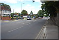
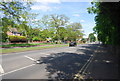
9
Ray Mead Road, Maidenhead
Houses on Ray Mead Road, Maidenhead.
Image: © Philip Halling
Taken: 6 Aug 2011
0.13 miles