IMAGES TAKEN NEAR TO
Lassell Gardens, MAIDENHEAD, SL6 8ND
Introduction
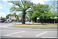
This page details the photographs taken nearby to Lassell Gardens, SL6 8ND by members of the Geograph project.
The Geograph project started in 2005 with the aim of publishing, organising and preserving representative images for every square kilometre of Great Britain, Ireland and the Isle of Man.

There are currently over 7.5m images from over14,400 individuals and you can help contribute to the project by visiting https://www.geograph.org.uk
Image Map
Images are licensed for reuse under creativecommons.org/licenses/by-sa/2.0
Notes
- Clicking on the map will re-center to the selected point.
- The higher the marker number, the further away the image location is from the centre of the postcode.
Image Listing (95 Images Found)
Images are licensed for reuse under creativecommons.org/licenses/by-sa/2.0
Image
Details
Distance
2
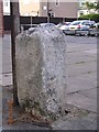
Old Boundary Marker by the A4, Bridge Road, Maidenhead parish
Parish Boundary Marker by the A4, in parish of Maidenhead (Windsor and Maidenhead District), Bridge Road, in front of former Barclays Bank (Maidenhead Bridge Branch) at junction with Lassell Gardens, on wide pavement beside phone box.
Surveyed
Milestone Society National ID: BE_LB26pb
Image: © Milestone Society
Taken: Unknown
0.06 miles