IMAGES TAKEN NEAR TO
Kidwells Close, MAIDENHEAD, SL6 8FZ
Introduction
This page details the photographs taken nearby to Kidwells Close, SL6 8FZ by members of the Geograph project.
The Geograph project started in 2005 with the aim of publishing, organising and preserving representative images for every square kilometre of Great Britain, Ireland and the Isle of Man.

There are currently over 7.5m images from over14,400 individuals and you can help contribute to the project by visiting https://www.geograph.org.uk
Image Map
Images are licensed for reuse under creativecommons.org/licenses/by-sa/2.0
Notes
- Clicking on the map will re-center to the selected point.
- The higher the marker number, the further away the image location is from the centre of the postcode.
Image Listing (117 Images Found)
Images are licensed for reuse under creativecommons.org/licenses/by-sa/2.0
Image
Details
Distance
3
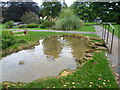
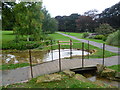
Kidwells Park, Maidenhead
Kidwells Park was gifted to the town of Maidenhead on 23rd July 1890 by JDM Pearce who was the Mayor of Maidenhead five times between 1856 and 1890.
This water feature is near the centre of the park.
Image: © Marathon
Taken: 22 Sep 2013
0.07 miles
4
Kidwells Park, Maidenhead
Kidwells Park was gifted to the town of Maidenhead on 23rd July 1890 by JDM Pearce who was the Mayor of Maidenhead five times between 1856 and 1890.
This water feature is near the centre of the park.
Image: © Marathon
Taken: 22 Sep 2013
0.07 miles
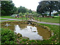
5
Water feature in Kidwells Park
Kidwells Park was gifted to the town of Maidenhead on 23rd July 1890 by JDM Pearce who was the Mayor of Maidenhead five times between 1856 and 1890.
This water feature is near the centre of the park.
Image: © Marathon
Taken: 22 Sep 2013
0.08 miles
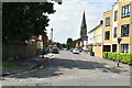
7
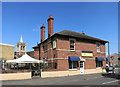
Diwa Indian Restaurant
On the corner of Norfolk and Cookham Roads. Looks like it was a pub at one time. St Joseph's church tower in the background.
Image: © Des Blenkinsopp
Taken: 30 Jul 2014
0.08 miles
8
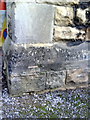
Benchmark on porch of St Luke's Church
Ordnance Survey cut mark benchmark described on the Bench Mark Database at http://www.bench-marks.org.uk/bm34559
Image: © Roger Templeman
Taken: 10 Dec 2010
0.10 miles
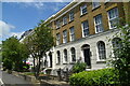
9
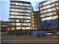
Offices on Bad Godesburg Way, Maidenhead
Image: © David Howard
Taken: 8 Jan 2018
0.10 miles
10
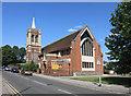
St Joseph's Church
Consecrated in 1914 this Catholic church on Cookham Road celebrated its centenary in May this year. http://www.stjosephsparish.co.uk/index.php/23-parish-activities/48-double-centenary-1914-2014-2114
Image: © Des Blenkinsopp
Taken: 30 Jul 2014
0.11 miles