IMAGES TAKEN NEAR TO
Reform Road, MAIDENHEAD, SL6 8EQ
Introduction
This page details the photographs taken nearby to Reform Road, SL6 8EQ by members of the Geograph project.
The Geograph project started in 2005 with the aim of publishing, organising and preserving representative images for every square kilometre of Great Britain, Ireland and the Isle of Man.

There are currently over 7.5m images from over14,400 individuals and you can help contribute to the project by visiting https://www.geograph.org.uk
Image Map
Images are licensed for reuse under creativecommons.org/licenses/by-sa/2.0
Notes
- Clicking on the map will re-center to the selected point.
- The higher the marker number, the further away the image location is from the centre of the postcode.
Image Listing (61 Images Found)
Images are licensed for reuse under creativecommons.org/licenses/by-sa/2.0
Image
Details
Distance
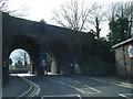
1
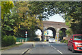
Railway bridge over B3028 Oldfield Road, Maidenhead
The three arches carry the main line out of Paddington.
Image: © Robin Webster
Taken: 26 Sep 2021
0.05 miles
3
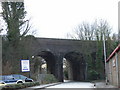
Railway bridge, Oldfield Road, Maidenhead
Image: © Andrew Smith
Taken: 1 Jan 2006
0.06 miles