IMAGES TAKEN NEAR TO
Moor Lane, MAIDENHEAD, SL6 7JX
Introduction
This page details the photographs taken nearby to Moor Lane, SL6 7JX by members of the Geograph project.
The Geograph project started in 2005 with the aim of publishing, organising and preserving representative images for every square kilometre of Great Britain, Ireland and the Isle of Man.

There are currently over 7.5m images from over14,400 individuals and you can help contribute to the project by visiting https://www.geograph.org.uk
Image Map
Images are licensed for reuse under creativecommons.org/licenses/by-sa/2.0
Notes
- Clicking on the map will re-center to the selected point.
- The higher the marker number, the further away the image location is from the centre of the postcode.
Image Listing (26 Images Found)
Images are licensed for reuse under creativecommons.org/licenses/by-sa/2.0
Image
Details
Distance
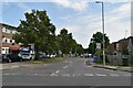
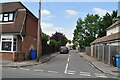
5
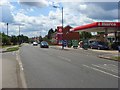
Cookham Road, Maidenhead
The B4447, a relatively busy route through residential north Maidenhead.
Image: © Andrew Smith
Taken: 15 Jun 2008
0.12 miles
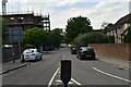
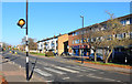
7
North Town Moor
A row of houses overlooking the National Trust owned North Town Moor, a small remnant of common land in north east of Maidenhead.
Image: © Ian Capper
Taken: 26 Nov 2010
0.17 miles
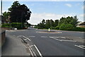
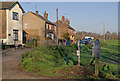
10
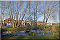
Pond, North Town Moor
A pond at the southern end of the National Trust owned North Town Moor, a small remnant of common land in north east of Maidenhead.
Image: © Ian Capper
Taken: 26 Nov 2010
0.18 miles