IMAGES TAKEN NEAR TO
Lees Close, MAIDENHEAD, SL6 4NU
Introduction
This page details the photographs taken nearby to Lees Close, SL6 4NU by members of the Geograph project.
The Geograph project started in 2005 with the aim of publishing, organising and preserving representative images for every square kilometre of Great Britain, Ireland and the Isle of Man.

There are currently over 7.5m images from over14,400 individuals and you can help contribute to the project by visiting https://www.geograph.org.uk
Image Map
Images are licensed for reuse under creativecommons.org/licenses/by-sa/2.0
Notes
- Clicking on the map will re-center to the selected point.
- The higher the marker number, the further away the image location is from the centre of the postcode.
Image Listing (10 Images Found)
Images are licensed for reuse under creativecommons.org/licenses/by-sa/2.0
Image
Details
Distance
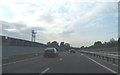
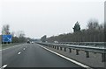
1

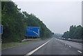
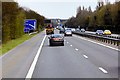
Cox Green : The A404(M)
Between Junction 9B (The Thicket) and 9A (Cox Green).
Image: © Lewis Clarke
Taken: 18 Jul 2019
0.03 miles
3
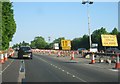
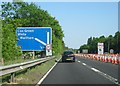
Slow going on the A404 (M)
The bridge over the main railway line to London is being rebuilt and the works have been in place for some time now.
Image: © Mr Ignavy
Taken: 25 Apr 2011
0.14 miles
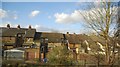
6
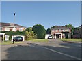
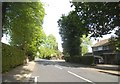
Timbers Walk - Tittle Row - Maidenhead
Smart modern detached houses in a cul-de-sac.
Image: © James Emmans
Taken: 24 Jun 2020
0.18 miles