IMAGES TAKEN NEAR TO
Dunholme End, MAIDENHEAD, SL6 3YP
Introduction
This page details the photographs taken nearby to Dunholme End, SL6 3YP by members of the Geograph project.
The Geograph project started in 2005 with the aim of publishing, organising and preserving representative images for every square kilometre of Great Britain, Ireland and the Isle of Man.

There are currently over 7.5m images from over14,400 individuals and you can help contribute to the project by visiting https://www.geograph.org.uk
Image Map
Images are licensed for reuse under creativecommons.org/licenses/by-sa/2.0
Notes
- Clicking on the map will re-center to the selected point.
- The higher the marker number, the further away the image location is from the centre of the postcode.
Image Listing (16 Images Found)
Images are licensed for reuse under creativecommons.org/licenses/by-sa/2.0
Image
Details
Distance
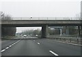
3
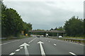
Shoppenhangers Road bridge over A404(M)
There is a slip road off the A404(M) beyond the bridge
Image: © David Smith
Taken: 26 Oct 2011
0.15 miles
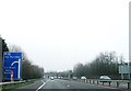
8
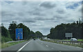
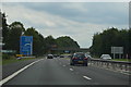
On the A404(M) approaching junction 9a, heading east
Image: © Rob Purvis
Taken: 14 Aug 2021
0.19 miles