IMAGES TAKEN NEAR TO
Purssell Close, MAIDENHEAD, SL6 3XU
Introduction
This page details the photographs taken nearby to Purssell Close, SL6 3XU by members of the Geograph project.
The Geograph project started in 2005 with the aim of publishing, organising and preserving representative images for every square kilometre of Great Britain, Ireland and the Isle of Man.

There are currently over 7.5m images from over14,400 individuals and you can help contribute to the project by visiting https://www.geograph.org.uk
Image Map
Images are licensed for reuse under creativecommons.org/licenses/by-sa/2.0
Notes
- Clicking on the map will re-center to the selected point.
- The higher the marker number, the further away the image location is from the centre of the postcode.
Image Listing (5 Images Found)
Images are licensed for reuse under creativecommons.org/licenses/by-sa/2.0
Image
Details
Distance
2

Maidenhead from the air
Looking over the town from the west.
Image: © Thomas Nugent
Taken: 19 May 2014
0.16 miles
5
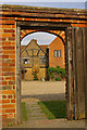
Through the arch
Part of Lillisbrooke Manor seen through an archway - for full picture and details of the Manor, see Image
Image: © Ian Capper
Taken: 5 Jun 2010
0.25 miles