IMAGES TAKEN NEAR TO
Bissley Drive, MAIDENHEAD, SL6 3UX
Introduction
This page details the photographs taken nearby to Bissley Drive, SL6 3UX by members of the Geograph project.
The Geograph project started in 2005 with the aim of publishing, organising and preserving representative images for every square kilometre of Great Britain, Ireland and the Isle of Man.

There are currently over 7.5m images from over14,400 individuals and you can help contribute to the project by visiting https://www.geograph.org.uk
Image Map
Images are licensed for reuse under creativecommons.org/licenses/by-sa/2.0
Notes
- Clicking on the map will re-center to the selected point.
- The higher the marker number, the further away the image location is from the centre of the postcode.
Image Listing (10 Images Found)
Images are licensed for reuse under creativecommons.org/licenses/by-sa/2.0
Image
Details
Distance
2
Cannon Lane, Woodlands Park
Railway Cottages at the junction with Breadcroft Lane.
Image: © Andrew Smith
Taken: 28 Jun 2008
0.07 miles
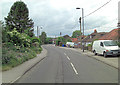
4

The western edge of Maidenhead
From Breadcroft Lane.
Image: © Andrew Smith
Taken: 13 Nov 2005
0.09 miles
5
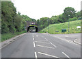
Cannon Lane passes under Reading to Maidenhead main line
Image: © Stuart Logan
Taken: 6 Jun 2012
0.17 miles
6
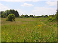
Grassland, Woodlands Park
A small area of common bounded by Cannon Lane, Breadcroft Lane and the railway.
Image: © Andrew Smith
Taken: 28 Jun 2008
0.19 miles
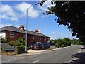
7
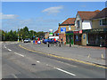
Waltham Road, Woodlands Park
On the approach to the junction with Cannon Lane. The row of shops includes a carpet retailer, Chinese takeaway, convenience store, pharmacy, newsagent and a firm of architects.
Image: © Andrew Smith
Taken: 28 Jun 2008
0.20 miles
8

Maidenhead from the air
Looking over the town from the west.
Image: © Thomas Nugent
Taken: 19 May 2014
0.20 miles
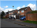
9

Willant Close, Woodlands Park, White Waltham
The western edge of the built up area with the bungalows on the left backing onto the airfield.
Image: © Andrew Smith
Taken: 8 Jun 2022
0.23 miles
10
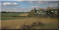
Edge of Maidenhead
Currently the western edge, anyway. On the right is one of the eight office buildings on Foundation Park, which has recently been "redeveloped". To its left is farmland stretching away towards Woolley Green. Seen from a train on the adjoining main line.
Image: © Derek Harper
Taken: 19 Mar 2012
0.25 miles