IMAGES TAKEN NEAR TO
Drift Road, MAIDENHEAD, SL6 3TZ
Introduction
This page details the photographs taken nearby to Drift Road, SL6 3TZ by members of the Geograph project.
The Geograph project started in 2005 with the aim of publishing, organising and preserving representative images for every square kilometre of Great Britain, Ireland and the Isle of Man.

There are currently over 7.5m images from over14,400 individuals and you can help contribute to the project by visiting https://www.geograph.org.uk
Image Map
Images are licensed for reuse under creativecommons.org/licenses/by-sa/2.0
Notes
- Clicking on the map will re-center to the selected point.
- The higher the marker number, the further away the image location is from the centre of the postcode.
Image Listing (6 Images Found)
Images are licensed for reuse under creativecommons.org/licenses/by-sa/2.0
Image
Details
Distance
1
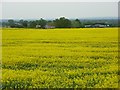
Farmland, Hawthorn Hill
Looking down on Hornbuckle Farm.
Image: © Andrew Smith
Taken: 5 May 2008
0.07 miles
2
The site of Pickins Farm
Some sort of quarrying goes on here.
Image: © Andrew Smith
Taken: 13 Nov 2005
0.13 miles
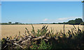
3
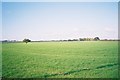
Flat east Berkshire farmland
Just off the Drift Road
Image: © Andrew Smith
Taken: 13 Nov 2005
0.20 miles
4
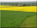
Farmland, Hawthorn Hill
A view over wheat and rape above Hornbuckle Farm from beside Fernygrove Copse.
Image: © Andrew Smith
Taken: 5 May 2008
0.23 miles
6
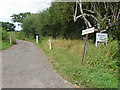
Farm access road
The access road the Bourne brook Farm from the Drift Road.
Image: © Alan Hunt
Taken: 27 Jul 2014
0.25 miles