IMAGES TAKEN NEAR TO
Drift Road, MAIDENHEAD, SL6 3TD
Introduction
This page details the photographs taken nearby to Drift Road, SL6 3TD by members of the Geograph project.
The Geograph project started in 2005 with the aim of publishing, organising and preserving representative images for every square kilometre of Great Britain, Ireland and the Isle of Man.

There are currently over 7.5m images from over14,400 individuals and you can help contribute to the project by visiting https://www.geograph.org.uk
Image Map
Images are licensed for reuse under creativecommons.org/licenses/by-sa/2.0
Notes
- Clicking on the map will re-center to the selected point.
- The higher the marker number, the further away the image location is from the centre of the postcode.
Image Listing (5 Images Found)
Images are licensed for reuse under creativecommons.org/licenses/by-sa/2.0
Image
Details
Distance
1
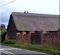
Birds of a Feather ?
These may look like two birds sitting on a roof but they have been constructed from pieces of the thatch.
Image: © Len Williams
Taken: 3 Sep 2015
0.07 miles
2
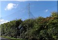
Driving range nets at Bird's Hill Golf Centre
Presumably to stop golf balls landing on cars on the A330.
Image: © Bikeboy
Taken: 12 Oct 2013
0.10 miles
3
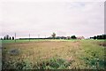
Bird Hills Golf Centre
The driving range and clubhouse.
Image: © Andrew Smith
Taken: 13 Nov 2005
0.20 miles
4
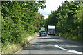
A330 towards Maidenhead
Horseboxes pass, the area seems quite horsey.
Image: © Robin Webster
Taken: 9 Jun 2019
0.21 miles
5
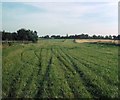
Former Racecourse, Hawthorn Hill
Situated on the A330 Ascot Road, this photo shows the finishing straight of the point-to-point course at Hawthorn Hill, which closed in the 1960s. A golf course now occupies this area, its postcode being SL6 3ST.
Image: © David Hillas
Taken: 15 Sep 1979
0.24 miles