IMAGES TAKEN NEAR TO
Breadcroft Lane, MAIDENHEAD, SL6 3QF
Introduction
This page details the photographs taken nearby to Breadcroft Lane, SL6 3QF by members of the Geograph project.
The Geograph project started in 2005 with the aim of publishing, organising and preserving representative images for every square kilometre of Great Britain, Ireland and the Isle of Man.

There are currently over 7.5m images from over14,400 individuals and you can help contribute to the project by visiting https://www.geograph.org.uk
Image Map
Images are licensed for reuse under creativecommons.org/licenses/by-sa/2.0
Notes
- Clicking on the map will re-center to the selected point.
- The higher the marker number, the further away the image location is from the centre of the postcode.
Image Listing (7 Images Found)
Images are licensed for reuse under creativecommons.org/licenses/by-sa/2.0
Image
Details
Distance
1
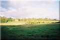
Countryside, from Breadcroft Lane
Looking northeast.
Image: © Andrew Smith
Taken: 13 Nov 2005
0.03 miles
2

Maidenhead from the air
Looking over the town from the west.
Image: © Thomas Nugent
Taken: 19 May 2014
0.04 miles
3
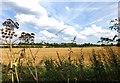
Fruit & Footpath
Some wild plums drooping over this path on a local nature reserve.
Image: © Des Blenkinsopp
Taken: 7 Aug 2014
0.12 miles
5
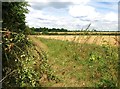
Field on the edge of town
The first buildings of Maidenhead are visible on the far side of this field.
Image: © Des Blenkinsopp
Taken: 7 Aug 2014
0.22 miles
6
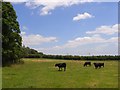
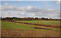
Cattle, Woolley Green
Pasture on one of the footpaths that heads towards the western edge of Maidenhead.
Image: © Andrew Smith
Taken: 28 Jun 2008
0.22 miles
7
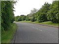
Westacott Way
The access road from the A4, bath road to the Maidenhead Business Park next to White Waltham airfield.
Image: © Alan Hunt
Taken: 31 May 2013
0.23 miles