IMAGES TAKEN NEAR TO
Wessex Way, MAIDENHEAD, SL6 3DL
Introduction
This page details the photographs taken nearby to Wessex Way, SL6 3DL by members of the Geograph project.
The Geograph project started in 2005 with the aim of publishing, organising and preserving representative images for every square kilometre of Great Britain, Ireland and the Isle of Man.

There are currently over 7.5m images from over14,400 individuals and you can help contribute to the project by visiting https://www.geograph.org.uk
Image Map
Images are licensed for reuse under creativecommons.org/licenses/by-sa/2.0
Notes
- Clicking on the map will re-center to the selected point.
- The higher the marker number, the further away the image location is from the centre of the postcode.
Image Listing (11 Images Found)
Images are licensed for reuse under creativecommons.org/licenses/by-sa/2.0
Image
Details
Distance

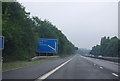
4

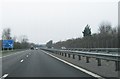
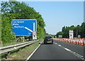
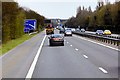
Cox Green : The A404(M)
Between Junction 9B (The Thicket) and 9A (Cox Green).
Image: © Lewis Clarke
Taken: 18 Jul 2019
0.17 miles
8
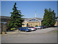
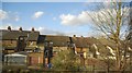
Cox Green Community Centre
On Highfield Road, the Community Centre's website is here http://www.coxgreencommunitycentre.org.uk/
Image: © Nigel Cox
Taken: 19 Jul 2006
0.22 miles
9
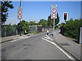
Cox Green: Highfield Lane bridge
The weak bridge over the main line railway to / from London Paddington.
Image: © Nigel Cox
Taken: 19 Jul 2006
0.22 miles
10
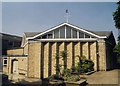
The Good Shepherd, Cox Green
Built in 1976.
Image: © Michael FORD
Taken: Unknown
0.22 miles