IMAGES TAKEN NEAR TO
Cresswells Mead, MAIDENHEAD, SL6 2YP
Introduction
This page details the photographs taken nearby to Cresswells Mead, SL6 2YP by members of the Geograph project.
The Geograph project started in 2005 with the aim of publishing, organising and preserving representative images for every square kilometre of Great Britain, Ireland and the Isle of Man.

There are currently over 7.5m images from over14,400 individuals and you can help contribute to the project by visiting https://www.geograph.org.uk
Image Map
Images are licensed for reuse under creativecommons.org/licenses/by-sa/2.0
Notes
- Clicking on the map will re-center to the selected point.
- The higher the marker number, the further away the image location is from the centre of the postcode.
Image Listing (15 Images Found)
Images are licensed for reuse under creativecommons.org/licenses/by-sa/2.0
Image
Details
Distance
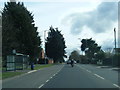
1
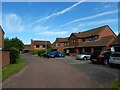
Holyport - Earlscourt
Modern detached housing in a cul-de-sac.
Image: © James Emmans
Taken: 11 Jun 2017
0.16 miles
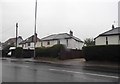
2
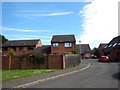
Holyport - Bucklebury Close
Modern houses.
Image: © James Emmans
Taken: 11 Jun 2017
0.17 miles
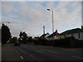
3
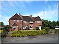
Holyport - Semi Detached Houses in Stompits Road
Image: © James Emmans
Taken: 11 Jun 2017
0.19 miles
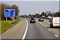
8
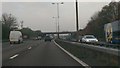
Windsor and Maidenhead : The M4 Motorway
Heading along the M4 Motorway as it heads through the Windsor and Maidenhead District.
Image: © Lewis Clarke
Taken: 30 Oct 2014
0.22 miles
9
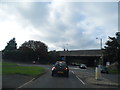
Windsor Road going under the M4 motorway
Image: © David Howard
Taken: 22 Sep 2013
0.23 miles