IMAGES TAKEN NEAR TO
Griffin Close, MAIDENHEAD, SL6 2RR
Introduction
This page details the photographs taken nearby to Griffin Close, SL6 2RR by members of the Geograph project.
The Geograph project started in 2005 with the aim of publishing, organising and preserving representative images for every square kilometre of Great Britain, Ireland and the Isle of Man.

There are currently over 7.5m images from over14,400 individuals and you can help contribute to the project by visiting https://www.geograph.org.uk
Image Map
Images are licensed for reuse under creativecommons.org/licenses/by-sa/2.0
Notes
- Clicking on the map will re-center to the selected point.
- The higher the marker number, the further away the image location is from the centre of the postcode.
Image Listing (7 Images Found)
Images are licensed for reuse under creativecommons.org/licenses/by-sa/2.0
Image
Details
Distance
1

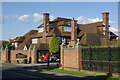
Larchfield Road
Semi-detached housing in the Maidenhead suburbs.
Image: © James Emmans
Taken: 24 Jun 2020
0.06 miles

5
Frederick's Hotel, Maidenhead
Hotel and spa located in an attractive house on Shoppenhagers Road.
Image: © Stephen McKay
Taken: 28 Jul 2012
0.22 miles
6

Finch Court - Maidenhead
Semi-detached housing in the suburban growth of Maidenhead.
Image: © James Emmans
Taken: 24 Jun 2020
0.23 miles
7
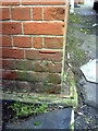
Benchmark on Desborough School, Shoppenhangers Road
Ordnance Survey cut mark benchmark described on the Bench Mark Database at http://www.bench-marks.org.uk/bm36248
Image: © Roger Templeman
Taken: 10 Dec 2010
0.23 miles