IMAGES TAKEN NEAR TO
Manor Lane, MAIDENHEAD, SL6 2QW
Introduction
This page details the photographs taken nearby to Manor Lane, SL6 2QW by members of the Geograph project.
The Geograph project started in 2005 with the aim of publishing, organising and preserving representative images for every square kilometre of Great Britain, Ireland and the Isle of Man.

There are currently over 7.5m images from over14,400 individuals and you can help contribute to the project by visiting https://www.geograph.org.uk
Image Map
Images are licensed for reuse under creativecommons.org/licenses/by-sa/2.0
Notes
- Clicking on the map will re-center to the selected point.
- The higher the marker number, the further away the image location is from the centre of the postcode.
Image Listing (25 Images Found)
Images are licensed for reuse under creativecommons.org/licenses/by-sa/2.0
Image
Details
Distance
1
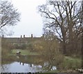
Shoppenhangers Manor House, Bray (1971)
An annex to the Esso Motor Hotel [Has since been acquired by Holiday Inn, but the annex had been demolished]. This garden pond with its 'duck house' was (is still?) an hotel lounge attraction.
Image: © Stanley Howe
Taken: Unknown
0.09 miles

3

Holiday Inn Maidenhead-Windsor
Large business hotel on the outskirts of Maidenhead, convenient for the M4.
Image: © Stephen McKay
Taken: 28 Jul 2012
0.14 miles
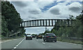
4
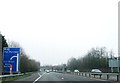
Cox Green : The A404(M)
Between Junction 9A (Cox Green) and Junction 8 (Holyport Interchange).
Image: © Lewis Clarke
Taken: 18 Jul 2019
0.15 miles
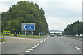

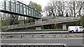
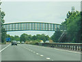
8

Kimbers Lane Footbridge over the A404(M)
Image: © David Dixon
Taken: 8 Apr 2015
0.18 miles