IMAGES TAKEN NEAR TO
Harvest Hill Road, MAIDENHEAD, SL6 2QH
Introduction
This page details the photographs taken nearby to Harvest Hill Road, SL6 2QH by members of the Geograph project.
The Geograph project started in 2005 with the aim of publishing, organising and preserving representative images for every square kilometre of Great Britain, Ireland and the Isle of Man.

There are currently over 7.5m images from over14,400 individuals and you can help contribute to the project by visiting https://www.geograph.org.uk
Image Map
Images are licensed for reuse under creativecommons.org/licenses/by-sa/2.0
Notes
- Clicking on the map will re-center to the selected point.
- The higher the marker number, the further away the image location is from the centre of the postcode.
Image Listing (9 Images Found)
Images are licensed for reuse under creativecommons.org/licenses/by-sa/2.0
Image
Details
Distance
1
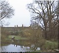
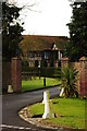
Shoppenhangers Manor House, Bray (1971)
An annex to the Esso Motor Hotel [Has since been acquired by Holiday Inn, but the annex had been demolished]. This garden pond with its 'duck house' was (is still?) an hotel lounge attraction.
Image: © Stanley Howe
Taken: Unknown
0.13 miles
2
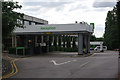
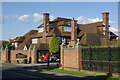
Holiday Inn Maidenhead-Windsor
Large business hotel on the outskirts of Maidenhead, convenient for the M4.
Image: © Stephen McKay
Taken: 28 Jul 2012
0.14 miles
6
Frederick's Hotel, Maidenhead
Hotel and spa located in an attractive house on Shoppenhagers Road.
Image: © Stephen McKay
Taken: 28 Jul 2012
0.23 miles
9
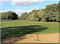
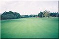
On Maidenhead Golf Course
A public footpath crosses the course just here.
Image: © Des Blenkinsopp
Taken: 29 Oct 2018
0.24 miles