IMAGES TAKEN NEAR TO
Courtlands, MAIDENHEAD, SL6 2PT
Introduction
This page details the photographs taken nearby to Courtlands, SL6 2PT by members of the Geograph project.
The Geograph project started in 2005 with the aim of publishing, organising and preserving representative images for every square kilometre of Great Britain, Ireland and the Isle of Man.

There are currently over 7.5m images from over14,400 individuals and you can help contribute to the project by visiting https://www.geograph.org.uk
Image Map
Images are licensed for reuse under creativecommons.org/licenses/by-sa/2.0
Notes
- Clicking on the map will re-center to the selected point.
- The higher the marker number, the further away the image location is from the centre of the postcode.
Image Listing (183 Images Found)
Images are licensed for reuse under creativecommons.org/licenses/by-sa/2.0
Image
Details
Distance
1
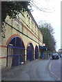
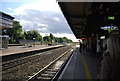
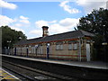
Back of railway station on Shoppenhangers Road
The gated arches are used as cycle parks.
Image: © Roger Templeman
Taken: 10 Dec 2010
0.02 miles
2
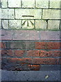
Benchmark on station building on Shoppenhangers Road
Ordnance Survey cut mark benchmark described on the Bench Mark Database at http://www.bench-marks.org.uk/bm36245
Image: © Roger Templeman
Taken: 10 Dec 2010
0.02 miles
3

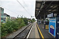
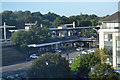
Maidenhead station
Although it was on the original line of the Great Western Railway, which opened as far as Reading in 1840, Maidenhead station did not open on its present site until 1st November 1871. The original Maidenhead station lay east of the River Thames, close to the present Taplow station. This was the line's first terminus, pending the completion of Maidenhead Railway Bridge across the Thames. The line from Maidenhead to High Wycombe was opened in 1854 but this now just runs to Marlow, trains having to reverse at Bourne End.
In this view from the down platform, the two fast lines are just ahead. The station building on the other side of the tracks is now disused as trains do not stop at this platform.
Image: © Marathon
Taken: 22 Sep 2013
0.02 miles
5
Disused building, Maidenhead station
The building on the rarely used platform 1 (Down fast) at Maidenhead station survives intact, though its canopy has been removed and the windows are boarded up.
Image: © Richard Vince
Taken: 7 Aug 2015
0.03 miles
7
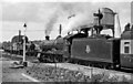
A 'Hall' and a 61XX at Maidenhead station
View NW, towards Reading, also High Wycombe; ex-GWR Paddington - Reading and the West main line, junction of branch to Bourne End and High Wycombe - closed beyond Bourne End from 4/5/70. At the Down Slow platform is 4-6-0 No. 6953 'Leighton Hall' (built 2/43, named 4/47, withdrawn 12/65) on a Paddington - Oxford stopping train, while 2-6-2T No. 6118 with a goods is coming off the branch from High Wycombe.
Image: © Ben Brooksbank
Taken: 25 Jul 1953
0.03 miles
8
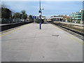
Maidenhead railway station, Berkshire, 2013
Opened in 1871 by the Great Western Railway on its line from London Paddington to Reading, this was the junction for the Wycombe Railway's line to Bourne End and High Wycombe (which now terminates at Marlow).
View west towards Twyford and Reading. See Image for a very different 2021 view from a similar position.
Image: © Nigel Thompson
Taken: 7 Feb 2013
0.03 miles
9
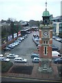
Victorian Clocktower
Picture of the clocktower (opened for Queen Victoria's Diamond Jubilee) with the railway station in the background. Picture is taken facing roughly west.
Image: © Martyn Davies
Taken: 10 Jan 2006
0.03 miles