IMAGES TAKEN NEAR TO
Meadow Way, MAIDENHEAD, SL6 2PE
Introduction
This page details the photographs taken nearby to Meadow Way, SL6 2PE by members of the Geograph project.
The Geograph project started in 2005 with the aim of publishing, organising and preserving representative images for every square kilometre of Great Britain, Ireland and the Isle of Man.

There are currently over 7.5m images from over14,400 individuals and you can help contribute to the project by visiting https://www.geograph.org.uk
Image Map
Images are licensed for reuse under creativecommons.org/licenses/by-sa/2.0
Notes
- Clicking on the map will re-center to the selected point.
- The higher the marker number, the further away the image location is from the centre of the postcode.
Image Listing (17 Images Found)
Images are licensed for reuse under creativecommons.org/licenses/by-sa/2.0
Image
Details
Distance
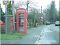
2
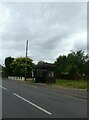
Flowers at the Bus Stop
Local people making the place look nice with flower baskets on the shelter.
Image: © Des Blenkinsopp
Taken: 7 Aug 2020
0.06 miles
4

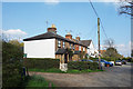
Hare and Hounds
Burnt-out pub in Fifield
Image: © Martyn Davies
Taken: 24 Jan 2006
0.10 miles
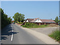
5
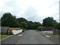
Looking along Manor Grove towards Fifield Road
Image: © Basher Eyre
Taken: 3 Jul 2024
0.15 miles
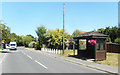
7
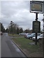
"The Fifield" Pub
Pub sign and view down Fifield's main street
Image: © Martyn Davies
Taken: 18 Jan 2006
0.15 miles
8
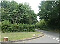
Navigating northwards up the Bashire (43)
Junction of Manor Grove and Fifield Road
Image: © Basher Eyre
Taken: 3 Jul 2024
0.15 miles
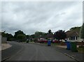
9
Fifield Road
Houses along Fifiled Road approaching the Village of Fifield.
Image: © Alan Hunt
Taken: 6 Jun 2013
0.16 miles