IMAGES TAKEN NEAR TO
Sturt Green, MAIDENHEAD, SL6 2JF
Introduction
This page details the photographs taken nearby to Sturt Green, SL6 2JF by members of the Geograph project.
The Geograph project started in 2005 with the aim of publishing, organising and preserving representative images for every square kilometre of Great Britain, Ireland and the Isle of Man.

There are currently over 7.5m images from over14,400 individuals and you can help contribute to the project by visiting https://www.geograph.org.uk
Image Map
Images are licensed for reuse under creativecommons.org/licenses/by-sa/2.0
Notes
- Clicking on the map will re-center to the selected point.
- The higher the marker number, the further away the image location is from the centre of the postcode.
Image Listing (5 Images Found)
Images are licensed for reuse under creativecommons.org/licenses/by-sa/2.0
Image
Details
Distance
1
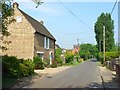
Stud Green
Stud Green is a single road of cottages and more modern houses. It isn't clear where the green is.
Image: © Andrew Smith
Taken: 22 May 2008
0.08 miles
2
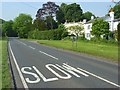
The A330, Holyport
On the approach to Stud Green.
Image: © Andrew Smith
Taken: 22 May 2008
0.14 miles
3

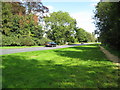
Wrought iron gates
The gates are the entrance to a large house. immediately after the gates,the track crosses a bridge over the stream named "The Bourne"
Image: © Bikeboy
Taken: 12 Oct 2013
0.18 miles
4
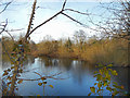
Fish Pond at Stud Green
Or Sturt Green, the map has both names just here. What is probably an old clay or gravel pit is now used for fishing. It's quite secluded. This is through a gap in the hedge.
Image: © Des Blenkinsopp
Taken: 9 Jan 2019
0.20 miles
5
Holyport: A330 Ascot Road
Viewed looking from Bournebridge towards Holyport.
Image: © Nigel Cox
Taken: 14 Sep 2008
0.20 miles