IMAGES TAKEN NEAR TO
Bartletts Lane, MAIDENHEAD, SL6 2JD
Introduction
This page details the photographs taken nearby to Bartletts Lane, SL6 2JD by members of the Geograph project.
The Geograph project started in 2005 with the aim of publishing, organising and preserving representative images for every square kilometre of Great Britain, Ireland and the Isle of Man.

There are currently over 7.5m images from over14,400 individuals and you can help contribute to the project by visiting https://www.geograph.org.uk
Image Map
Images are licensed for reuse under creativecommons.org/licenses/by-sa/2.0
Notes
- Clicking on the map will re-center to the selected point.
- The higher the marker number, the further away the image location is from the centre of the postcode.
Image Listing (7 Images Found)
Images are licensed for reuse under creativecommons.org/licenses/by-sa/2.0
Image
Details
Distance
1
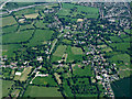
Holyport from the air
Stud Green is on the left. On approach to Heathrow from the west.
Image: © Thomas Nugent
Taken: 19 May 2014
0.09 miles
2
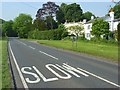
The A330, Holyport
On the approach to Stud Green.
Image: © Andrew Smith
Taken: 22 May 2008
0.10 miles
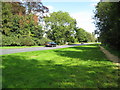
3

Wrought iron gates
The gates are the entrance to a large house. immediately after the gates,the track crosses a bridge over the stream named "The Bourne"
Image: © Bikeboy
Taken: 12 Oct 2013
0.11 miles
4
Holyport: A330 Ascot Road
Viewed looking from Bournebridge towards Holyport.
Image: © Nigel Cox
Taken: 14 Sep 2008
0.12 miles
5
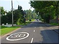
Moneyrow Green, Holyport
A leafy residential road leading towards the village centre. The green is a recreation ground on the left.
Image: © Andrew Smith
Taken: 22 May 2008
0.15 miles
6
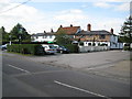
Holyport: The White Hart, Moneyrow Green
Haunted by a woman dressed in grey carrying a small baby... apparently.
Image: © Nigel Cox
Taken: 14 Sep 2008
0.21 miles
7
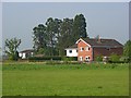
Houses, Holyport
To the south of Moneyrow Green and viewed from a footpath to the east.
Image: © Andrew Smith
Taken: 22 May 2008
0.21 miles