IMAGES TAKEN NEAR TO
Priors Way, MAIDENHEAD, SL6 2HP
Introduction
This page details the photographs taken nearby to Priors Way, SL6 2HP by members of the Geograph project.
The Geograph project started in 2005 with the aim of publishing, organising and preserving representative images for every square kilometre of Great Britain, Ireland and the Isle of Man.

There are currently over 7.5m images from over14,400 individuals and you can help contribute to the project by visiting https://www.geograph.org.uk
Image Map
Images are licensed for reuse under creativecommons.org/licenses/by-sa/2.0
Notes
- Clicking on the map will re-center to the selected point.
- The higher the marker number, the further away the image location is from the centre of the postcode.
Image Listing (18 Images Found)
Images are licensed for reuse under creativecommons.org/licenses/by-sa/2.0
Image
Details
Distance
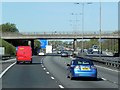
1
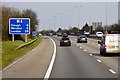
The M4, Bray
Viewed from the bridge on the A330 between Bray Wick and Holyport with a rush-hour queue on the London-bound carriageway.
Image: © Andrew Smith
Taken: 22 May 2008
0.03 miles
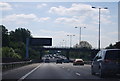
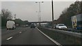
4
M4 near Bray
Eastbound, between junctions 8/9 and 7
Image: © MrC
Taken: 2 Nov 2012
0.13 miles
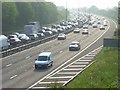
5
Windsor and Maidenhead : The M4 Motorway
Heading along the M4 Motorway as it heads through the Windsor and Maidenhead District.
Image: © Lewis Clarke
Taken: 30 Oct 2014
0.14 miles
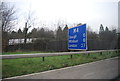
6
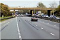
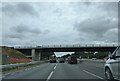
M4, Ascot Road Bridge
A330 (Ascot Road) passing over the M4 motorway.
Image: © David Dixon
Taken: 8 Apr 2015
0.16 miles
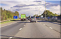
8
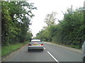
Windsor Road, Bray Wick
The queue was for temporary traffic lights.
Image: © David Howard
Taken: 22 Sep 2013
0.16 miles