IMAGES TAKEN NEAR TO
Monkey Island Lane, MAIDENHEAD, SL6 2EA
Introduction
This page details the photographs taken nearby to Monkey Island Lane, SL6 2EA by members of the Geograph project.
The Geograph project started in 2005 with the aim of publishing, organising and preserving representative images for every square kilometre of Great Britain, Ireland and the Isle of Man.

There are currently over 7.5m images from over14,400 individuals and you can help contribute to the project by visiting https://www.geograph.org.uk
Image Map
Images are licensed for reuse under creativecommons.org/licenses/by-sa/2.0
Notes
- Clicking on the map will re-center to the selected point.
- The higher the marker number, the further away the image location is from the centre of the postcode.
Image Listing (14 Images Found)
Images are licensed for reuse under creativecommons.org/licenses/by-sa/2.0
Image
Details
Distance
1
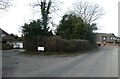
Junction of Monkey Island Court and Monkey Island Lane
Image: © Basher Eyre
Taken: 5 Feb 2022
0.08 miles

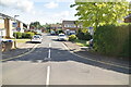


8

A308 Windsor Road
Towards Maidenhead from Windsor.
Image: © Robin Webster
Taken: 22 Mar 2020
0.14 miles
9
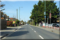
A308 Windsor Road
Towards Maidenhead from Windsor.
Image: © Robin Webster
Taken: 22 Mar 2020
0.18 miles
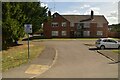
10

Holyport - Oakley Gardens
Large detached new houses in cal-de-sac.
Image: © James Emmans
Taken: 11 Jun 2017
0.20 miles