IMAGES TAKEN NEAR TO
St. Ives Road, MAIDENHEAD, SL6 1SG
Introduction
This page details the photographs taken nearby to St. Ives Road, SL6 1SG by members of the Geograph project.
The Geograph project started in 2005 with the aim of publishing, organising and preserving representative images for every square kilometre of Great Britain, Ireland and the Isle of Man.

There are currently over 7.5m images from over14,400 individuals and you can help contribute to the project by visiting https://www.geograph.org.uk
Image Map
Images are licensed for reuse under creativecommons.org/licenses/by-sa/2.0
Notes
- Clicking on the map will re-center to the selected point.
- The higher the marker number, the further away the image location is from the centre of the postcode.
Image Listing (255 Images Found)
Images are licensed for reuse under creativecommons.org/licenses/by-sa/2.0
Image
Details
Distance
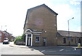
3
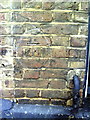
Benchmark on The Anchor pub, York Road
Ordnance Survey cut mark benchmark described on the Bench Mark Database at http://www.bench-marks.org.uk/bm36250
Image: © Roger Templeman
Taken: 10 Dec 2010
0.04 miles
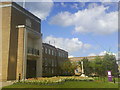
5
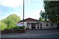
Maidenhead Heritage Centre
View of Maidenhead Heritage Centre in April 2009 after considerable refurbishment.
Image: © John Raine
Taken: 14 Apr 2009
0.05 miles
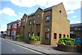
10
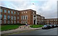
Maidenhead Town Hall
In St. Ives Road, home to The Royal Borough of Windsor and Maidenhead.
Image: © Graham Horn
Taken: 21 Jan 2008
0.05 miles