IMAGES TAKEN NEAR TO
High Street, MAIDENHEAD, SL6 1PY
Introduction
This page details the photographs taken nearby to High Street, SL6 1PY by members of the Geograph project.
The Geograph project started in 2005 with the aim of publishing, organising and preserving representative images for every square kilometre of Great Britain, Ireland and the Isle of Man.

There are currently over 7.5m images from over14,400 individuals and you can help contribute to the project by visiting https://www.geograph.org.uk
Image Map
Images are licensed for reuse under creativecommons.org/licenses/by-sa/2.0
Notes
- Clicking on the map will re-center to the selected point.
- The higher the marker number, the further away the image location is from the centre of the postcode.
Image Listing (230 Images Found)
Images are licensed for reuse under creativecommons.org/licenses/by-sa/2.0
Image
Details
Distance
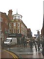
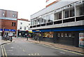
2
View along the pedestrianised part of High Street
Image: © Roger Templeman
Taken: 10 Dec 2010
0.02 miles
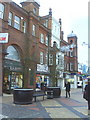
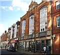
4
Maidenhead High Street
Originally the main London to Bath road but now pedestrianised and virtually indistinguishable from any other mediocre town centre.
Image: © Rod Allday
Taken: 27 Aug 2008
0.04 miles
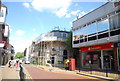
6
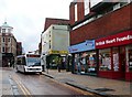
High Street, Maidenhead
Most of the High Street behind the bus is pedestrianised. This section is available for buses and access.
Image: © Graham Horn
Taken: 21 Jan 2008
0.05 miles
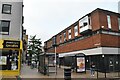
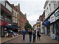
9
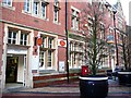
Maidenhead post office
On High Street. This post office was never in danger of being added to the closure list.
Image: © Graham Horn
Taken: 21 Jan 2008
0.06 miles
