IMAGES TAKEN NEAR TO
North Road, MAIDENHEAD, SL6 1PE
Introduction
This page details the photographs taken nearby to North Road, SL6 1PE by members of the Geograph project.
The Geograph project started in 2005 with the aim of publishing, organising and preserving representative images for every square kilometre of Great Britain, Ireland and the Isle of Man.

There are currently over 7.5m images from over14,400 individuals and you can help contribute to the project by visiting https://www.geograph.org.uk
Image Map
Images are licensed for reuse under creativecommons.org/licenses/by-sa/2.0
Notes
- Clicking on the map will re-center to the selected point.
- The higher the marker number, the further away the image location is from the centre of the postcode.
Image Listing (72 Images Found)
Images are licensed for reuse under creativecommons.org/licenses/by-sa/2.0
Image
Details
Distance
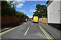
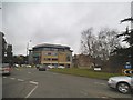
4
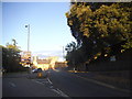
Roundabout on the A4, Maidenhead
The LED sign is for the town centre car parks, as unlike normal signs can be changed to show how many spaces are free at any moment in time.
Image: © David Howard
Taken: 9 Aug 2015
0.12 miles
9
Roundabout on Frascati Way, Maidenhead
Image: © David Howard
Taken: 21 Feb 2016
0.14 miles
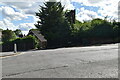
10
Maidenhead Christian Scientist Church
Diagonally opposite the Methodists on the other side of the roundabout.
Image: © Des Blenkinsopp
Taken: 30 Jul 2014
0.14 miles