IMAGES TAKEN NEAR TO
Nicholsons Walk, MAIDENHEAD, SL6 1LL
Introduction
This page details the photographs taken nearby to Nicholsons Walk, SL6 1LL by members of the Geograph project.
The Geograph project started in 2005 with the aim of publishing, organising and preserving representative images for every square kilometre of Great Britain, Ireland and the Isle of Man.

There are currently over 7.5m images from over14,400 individuals and you can help contribute to the project by visiting https://www.geograph.org.uk
Image Map
Images are licensed for reuse under creativecommons.org/licenses/by-sa/2.0
Notes
- Clicking on the map will re-center to the selected point.
- The higher the marker number, the further away the image location is from the centre of the postcode.
Image Listing (294 Images Found)
Images are licensed for reuse under creativecommons.org/licenses/by-sa/2.0
Image
Details
Distance
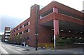
2
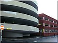
Nicholson Centre car park
Two contrasting shapes to this building; the circular concrete ramps and the square brick-faced parking decks. "Low headroom" is an understatement. This is not the main entrance!
Image: © Graham Horn
Taken: 21 Jan 2008
0.05 miles
3
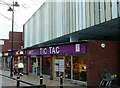
Ticky tacky area of Maidenhead?
Actually TIC TAC is the Maidenhead branch of Connexions, providing advice for young people across Berkshire. This is in King Street, underneath the Nicholson Centre car park.
Image: © Graham Horn
Taken: 21 Jan 2008
0.05 miles