IMAGES TAKEN NEAR TO
Kingswood Court, MAIDENHEAD, SL6 1DB
Introduction
This page details the photographs taken nearby to Kingswood Court, SL6 1DB by members of the Geograph project.
The Geograph project started in 2005 with the aim of publishing, organising and preserving representative images for every square kilometre of Great Britain, Ireland and the Isle of Man.

There are currently over 7.5m images from over14,400 individuals and you can help contribute to the project by visiting https://www.geograph.org.uk
Image Map
Images are licensed for reuse under creativecommons.org/licenses/by-sa/2.0
Notes
- Clicking on the map will re-center to the selected point.
- The higher the marker number, the further away the image location is from the centre of the postcode.
Image Listing (15 Images Found)
Images are licensed for reuse under creativecommons.org/licenses/by-sa/2.0
Image
Details
Distance
2
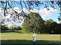
Waymark on the Golf Course
The footpath over Maidenhead Golf Course is clearly marked.
Image: © Des Blenkinsopp
Taken: 29 Oct 2018
0.13 miles

4

Benchmark on brick pillar on side of #42 Braywick Road
Ordnance Survey cut mark benchmark described on the Bench Mark Database at http://www.bench-marks.org.uk/bm36247
Image: © Roger Templeman
Taken: 10 Dec 2010
0.15 miles
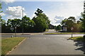
5
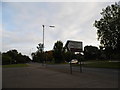
Braywick Road at the entrance to the sports ground
Image: © David Howard
Taken: 22 Sep 2013
0.15 miles
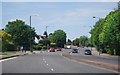
8
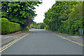
Braywick Road, Maidenhead
This seems to be the original route of the A308, which now runs in parallel as a dual carriageway just off to the right.
Image: © Robin Webster
Taken: 9 Jun 2019
0.18 miles
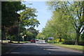
10
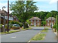
Walker Road, Bray Wick, Maidenhead
A 'desirable' residential area on the southern edge of the town.
Image: © Andrew Smith
Taken: 21 May 2011
0.21 miles